

Introduction
Overview
We have attempted to relate these site to the history of the region
through a series of short articles on:
1. Historic Claims of the area
2. Analysis Critera - Where
sites fit
in terms of the Community
Heritage
3. Community Layout
4. Notable People
The project is intended as a "Beginning" rather than a Finished
Product.
Local groups and individuals are invited to amend and add to it. New
information is always welcome and we will make every effort to add
anthing that is sent to us.
One goal is to collect as much information about our older
buildings as we can. This will be found in the Sites section, and we
would appreciate corrections, additions, comments and questions as we
complete the project.
Community Historical
Claims
The Municipality of Two Borders was formed in 2015 from the former
Municipalities of Arthur, Albert and Edward. Aptly named, it occupied a
huge expanse of land in the southwest corner of Manitoba along the
borders with North Dakota and Saskatchewan.
By the end of the settlement era three sets of railway tracks accessed
the region. In the early1890’s, the CPR line had been extended from
Brandon, through Napinka and Melita, then on to Elva and Pierson. In
1902 a branch of the CNR cut across the southern reaches putting
Coulter and Lyleton on the map. About 1906 the CPR extended a branch
from Lauder through Bernice, Bede, Broomhill and Tilston. By that time
farmers throughout the municipality had reliable connections with the
rest of the province allowing much easier marketing of their produce
and much improved access to agricultural equipment and consumer goods.
While these first towns may not have appeared until after 1890, the
region itself already had a long and interesting history. The wooded
valley of the Souris had long been a place of shelter, a gathering
place for various aboriginal peoples and a buffalo hunting
ground.
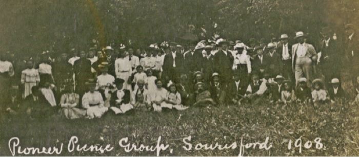
Sourisford was the first settlement in the region. Here
the locals celebrate at the 1908 Pioneer Picnic.
Prior to the arrival of the Euro-settlers the region was linked to the
rest of the province by two trails. The Yellowquill trail, starting
near Portage and running along parts of the Souris River towards what
is now the southwest corner of the province, had long been used by
Aboriginal bands, Metis hunters, and fur traders. The Boundary
Commission crossed the southern reaches of the territory in 1874 and
the trail and crossings they left were used by the first Euro- settlers
to head west from Emerson.
In 1879 The Elliotts and Goulds settled at Sourisford, the crossing of
the Souris established by the Boundary Commission.
Some of these first settlers came with the hope that a rail line would
soon cross the district. In the meantime they had to make long trips
for supplies and to market their produce. That didn’t stop them from
establishing farms, schools and churches, raising families and
generally getting on with life.
About 1881 a little village called Manchester developed, just over a
kilometre west of where Melita now sits. Services included a store,
post office and blacksmith shop. Resourceful entrepreneurs promoted it
as an investment opportunity during the Manitoba Boom of 1881-1882, but
it remained a tiny village. When locals applied for a Post Office they
were told that the name was taken and the name Melita was chosen. A few
years late the little village moved to the new rail line and became a
town.
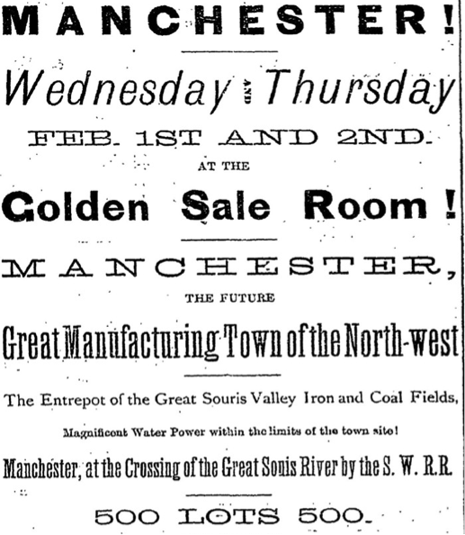
Manchester Ad from 1882.
Later in 1881 more settlers, mainly from Ontario, approached the
district from the north having taken the new CPR line west from
Winnipeg as far as it went, and using oxen to haul their goods the rest
of the way. The beginning of regular railway service to Brandon
brought many more in the spring of 1882, also mainly from Ontario. The
area was well settled by the time the railway arrived in 1890.
For the first ten years after farming operations commenced, the
scattered rural nature of settlement in the area was characterized by
various small rural centres: often just a post office, usually in a
farm home; and perhaps a school which might double as a church and
community hall. Copley, Broomhill, Eunola, and Menota, were such
communities.
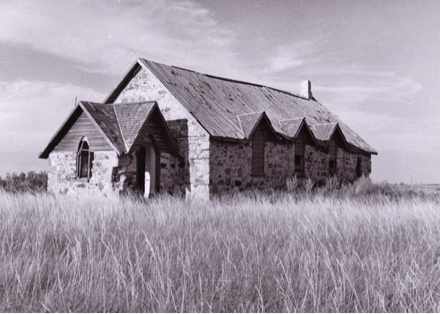
The region’s first church: St. George’s Anglican Church, Copley, built
in 1892
Across Manitoba the arrival of rail lines triggered the creation of
villages, typically composed of a railway station, elevator(s) and a
cluster of services. Schools and post offices were then generally moved
to new locations in the village.
By the 1920’s roads were already beginning to replace
some of the rail traffic.
The establishment in the early 1890’s of the towns of Melita, Elva and
Pierson in the midst of this well-populated and productive farmland led
to an initial burst of commercial enterprises. The usual banks, general
stores, drug and jewellery stores appeared. Additional lines added more
villages. As the CN extended westward from Waskada, Coulter and Lyleton
became villages while Dalny and Cameron remained sidings. The CP line
westward from Lauder created stops at Bernice and Bede, an embryo
village at Broomhill, and a substantial village at Tilston.
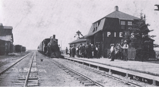
Pierson in 1905.
The towns of Pierson and Melita were the first towns in the region and
they remain the dominant commercial centres today. Elva Tilston,
Coulter, Lyleton fulfilled an important economic and social role as did
Bernice, Bede and Broomhill.
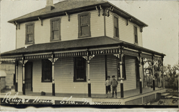
A fine home in Elva
The re-alignment of communities around the new villages changed the
dynamics of commercial, social, and spiritual life. Religious services
that had taken place in homes and schools were moved to the newly
erected Churches. Grain and livestock need only be taken as far as the
railway station. Shopping for consumer goods and agricultural supplies
was done in local outlets. Dances, performances and all manners of
entertainment and cultural activities moved to community halls. All
these things and more made the village the community focal point.
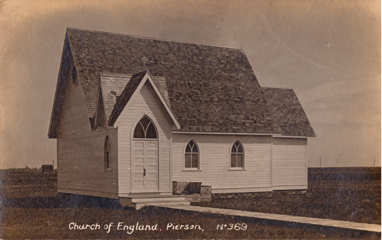
Church of England, Pierson
The commercial utility of these centres faded as the improved mobility
of consumers, the “rationalization” of rail lines and grain delivery,
and the changing nature of farming each had its impact. Their
social/cultural role as centres of community activities is still
evident. Although no retail services remain in Coulter, Elva, Lyleton
and Tilston, each retains some of its village character.
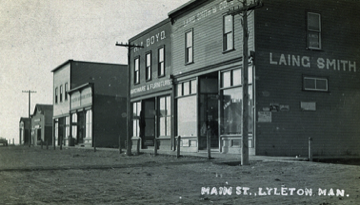
Lyleton’s Main Street
The exploitation of regional oil reserves has created a renewed
economic activity in the area, the full results of which are yet to be
seen.
In the early years of the twentieth century Melita consolidated its
position as the primary trading centre for the region while Pierson,
though a vibrant community, offered more limited commercial services.
Analysis Criteria
Aboriginal Peoples
When the first settlers arrived in the region it was obvious to them
that they were not the first inhabitants of this land. Native people
often passed through and evidence of past inhabitants was more visible
in those days, be it in the form of campsites and prairie trails.
Settlers often encountered and interacted with the Dakota people from
the Turtle Mountain and Oak Lake areas.
Settlers and Defining Culture
Anticipating the great settlement boom of the 1880’s a trickle of
adventurous souls lead the way into this land in the late 1870’s.
The Souris River valley was attractive in that it provided ample water
as well logs for building and fuel.
Until 1889 settlement focused on the settlements at Sourisford and
Melita and scattered post offices such as Butterfield and Napinka.
Settlers first approached the district taking the Boundary Commission
Trail from Emerson. When rail service reached Brandon in late 1881 that
route became popular. Local histories indicate that most of these early
settlers came from Ontario.
Other Settlement/Ethnic Groups
The establishment of the railway though the region eventually altered
the predominantly Anglo-Saxon settlement somewhat, but many Two Borders
families can trace their roots back to Ontario.
Economic Engines
Farming formed the economic basis of virtually all prairie settlements
but many communities have succeeded in establishing relatively
small-scale but significant economic engines, generally related to
agriculture and local resource development.
Commercial Growth
The establishment in 1890 of the towns of Melita and Pierson in the
midst of well-populated and productive farmland led to an initial burst
of commercial enterprises. The usual banks, general stores, drug and
jewelry stores appeared. Some of these would naturally be housed in
quickly erected-frame buildings, but because the economic importance of
the towns seemed quite secure, many substantial commercial and
residential buildings appeared in those first years.
Community Form and Layout
The layouts of the towns of Pierson. Elva, Lyleton, Coulter, and
Tilston were a direct response to the railway line to which each owes
its existence.
Pierson
The railway runs west-east and the town was surveyed to conform.
Broadway Avenue, which quickly evolved into the “Main” business street
runs perpendicular to the tracks and away from the station. That street
soon housed a wide variety of retail and service outlets. More avenues
spread to the east and west to accommodate a rising need for
residences.
The orientation of streets in a railway town often conforms to the
direction of the rail line. If the line passes through in a
southwesterly direction, a “Railway Avenue” will run parallel to it –
with a grid of side streets conforming to the orientation. The
alternative is to ignore the direction of the railway and to orient
streets in a north-south, east west grid.
Elva
The streets in Elva use the former system, with two avenues oriented to
the southwesterly direction of the rail line and seven streets
intersecting to form a long narrow rectangle. Railway Avenue became the
primary business street.
Lyleton
The rail line runs in an east west direction through Lyleton allowing
both an orientation with the rail line and an orderly north-south and
east west grid of streets. In this case one of the “side” streets,
Souris Street, became the location for most businesses.
Tilston
Tilston also has a Railway Avenue running east-west with commercial
activity primarily on a side street (Morris).
Coulter
The rail runs in a southwesterly direction through Coulter. Two avenues
run parallel to it, one on each side of the track and two short side
streets complete the layout for this tiny village.
Notable
Citizens in the Municipality of Two Borders
Breakey, Norman
Inventor of the Paint Roller, grew up in Pierson. His family started
one of the early Boarding Houses.
Dobbyn, John
Mr. Dobbyn had “Dobbyn City” surveyed on 36-3-27 in anticipation
of a coming rail line.
Dodds, G.L.
Mr. Dodds had a Hardware & General store in Manchester. He moved to
the new townsite in 1890. He served as a Land Agent for CPR and Canada
North West Land Co. He sold farms and traveled to Ontario to solicit
settlers.
Dandy, James
First Postmaster, noted businessman, community leader in Pierson.
Dann, Henry
Postmaster at Butterfield, 1884.
Duncan, James
James Duncan worked as a blacksmith at Manchester in the early 1880’s.
Elliot, Gordon
Mr. Gordon worked with Prof. Montgomery of Toronto in 1913-14 he while
he was at Sourisford, excavating mounds of the “Mound Builders”. Two
years later worked with W.B. Nickerson of the Archaeological Survey
looking at mounds in the Snowflake, Alexander & Arden areas.
Elliot, J.B.
Sourisford pioneer of 1879. Operated a Stopping House.
Fulton,
The Fulton family operated a cooperative farm which the locals called
“Fultonville”, northwest of Pierson.
Gould, Alf
Sourisford Pioneer, Postmaster. Opened stores in Sourisford, Coulter
and Pierson.
Henderson, Joseph
First Reeve of the R.M. of Edward, 1905 – 1907
Graham, R.M
Mr. Graham arrived in 1882 and set up a store and post office in 1883,
followed by a blacksmith’s shop that he rented out. The site became the
village of Manchester – soon changed to Melita. In 1891 he bought a
store in Melita from Coughill.
Kilkenny, William
Built and operated the Broomhill store in 1908. In the Kilkenny family
until it closed in 1964.
Large, Captain Rolston
Captain Large built the Empress of Ireland, a steam powered boat that
saw service on the Souris River in 1909, 1910.
Livingston, Dr. A.M.
Dr. Livingston had property near Melita / Manchester (Livingston’s
Crossing?)
Lyle, Andrew
Postmaster at Lyleton, 1890
Morrison, Dr. John
First resident Doctor in Pierson, 1891. Appointed Provincial Coroner in
1906.
Pierson, Jean Louis
Dutch financier, and C.P.R investor.
Thomas, W.F.
Mr. Thomas was a pioneer and ferry service operator. He served as the
original clerk of the new Municipality of Arthur – a position he held
for nearly 50 years. Mr. Thomas was first settler to build a
house in the area (1881).
Salisbury, John
John Salisbury homesteaded E 32-4-26 in 1883
Sinclair, Dr.
Dr. Sinclair developed the townsite of Manchester on 32-3-26.
Williams, John
Mr. Williams was the earliest settler on the “Penninsula” south of
Melita. He was a Councilor (1882), Reeve, and MLA (1907). He became
Minister of Agriculture in 1922.
West, Charles
Charles was living in a dugout shanty on the west bank of the Souris
River when Walter F. Thomas, James Kinley and Alfred Dugay arrived in
1879.
|
|