 |
Photos - Coulter Park - Documents - News Archive
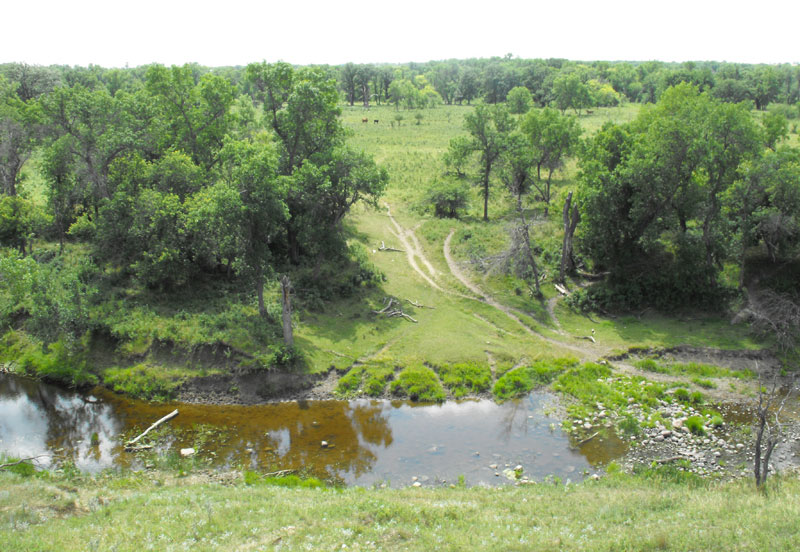
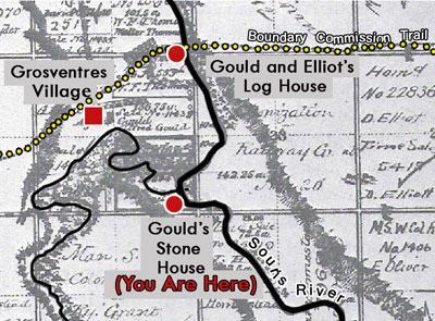
The Crossing In 1873 The Boundary Commission, on its westward trek thriough southwestern Manitoba, chose a natural crossing on the Souris River that had existed for centuries. Bison herds in their yearly migrations, Aboriginal Peoples on their hunting trips, fur traders and Metis pemmican brigades; each had used the site. A gravel bottom spans the width of the river and the soft banks on either side were worn down by herds of bison. The bank of this portion of the river was a popular camping place for First Nations and the location of impermanent villages. It was also a camping place for early explorers, the Boundary Commission Surveyors, and the North West Mounted Police. The convenient river crossing that came to be called Sourisford, is near the crossroads of ancient trading routes used by First Nations groups. One, which passed from the Turtle Mountain westward, was adapted by the Boundary Commission; the other, the Yellowquill Trail, angled southwest from the Portage La Prairie area. The first villages in southern Manitoba were established alongside the Trail, flourishing until the railroad came to the area. In late 1879 Walter F. Thomas came by way of Winnipeg, and in the spring of 1880 Alfred Gould and David Elliott arrived using the Boundary Commission Trail. Gould and Elliot built a house and barn at the crossing along the trail, near the river. With the increase of settlement travel westward, their home became established as a regular “stopping place.” The stopping place slowly grew into a small unofficial community. During the summer of 1882 a store was operated out of a tent by settlers Warren and Snider. A regular post office called “Sourisford” was installed the next year. T. B. Gerry opened a blacksmith shop and F. B. Warren opened a store which operated for two or three years. In rural Manitoba the arrival of the railway changed everything. The Community Souisford was poised to become the service centre for the region. If the railway line that connected Brandon with southeastern Saskatchewan in 1890 had crossed the Souris River here instead of Melita, a major town would have grown here and Melita would have faded. But Sourisford remained a rural community with its Post Office and Store – offering the necessary basic services, until 1901 when another CPR branch stretched westward from Waskada and established Coulter a few kilometres away. Sourisford became one of dozens of Westman communities that had served its purpose and was no longer needed as a commercial centre. It did however remain its identity as a community. Coulter Park Today, Coiulter Park just south of the original crossing, the site of the features well-used campground, several Heritage Displays have kept the name "Sourisford" alive. It is the location of one of the earliest regularly used recreation sites in rural Manitoba. On July 1, 1882, the first Pioneer Picnic was attended by a few settlers and local aboriginals. A tradition was established as each year a larger group attended the Picnic. Since then, picnics have been held in the grove every summer. These gatherings used to attract thousands of locals and visitors alike, many from the United States. Bannock with syrup would be served up, along with a dinner laid out on blankets in true picnic style. Short addresses were sometimes given before a band played to liven things up. http://www.virtualmanitoba.com/sourisford/ |

The trail of the Boundary Commisssion


| Links Against All Odds Kitchen Table Surgery The Brockinton Site Sourisford: The History of a River Crossing Linear Mounds |
 MapPlus... |