
 |
 |

Fort
Ellice

A
quick glance at a modern map tells us which towns and cities are large
and
which
are small. Major transportation routes can quickly be inferred,
and in
general
we can get a feel for a region. A quick glance at almost any map
of
British North America in the mid 1800’s, for instance would be
enough for
the casual observer to make the assumption that Fort Ellice was a
location
of some importance. Then, as now, font size alone tells us
something,
and on Palliser’s map, reflecting his journeys of 1857-59, Fort
Ellice is
prominent.[1] It is instantly recognizable as an
important juntion on a network of well marked trails. When
planning was underway for the railway, many assumed it would follow the
old Carleton Trail and that Fort Ellice would make the transition from
regional Hudson Bay Company post to prairie city. It almost happenned,
but today, although the name survives as the identity of the
surrounding municipality, the site itself doesn't appear on the
average road map.

Palliser Map
http://www.flickr.com/photos/manitobamaps/2211818555/
A Section of a General Map of the Routes in British North America
Explored by the Expedition Under Captain Palliser (1865)
The
early 1800’s was a time of realignment for the fur trade in
the West Local fur-bearing species had been in some cases been
exhausted, competition was fierce and the traders were reaching out to
various native tribes in an effort to attract their business. Posts
sprang up and disappeared in short spans of time. The nature of the
trade in southern Manitoba focused more on the provision of pemmican
for the most distant posts than on actual gathering of furs and some
posts evolved into way stations, central distribution or administration
points, and even retail and service centres. Others were closed. By
1870 when the first trickle settlers began to venture west of Portage
no posts existed in the southwestern corner Manitoba and the H.B.C.
maintained only a limited presence in the area we now refer to as
Western Manitoba.
By virtue of its location at the crossing of the Carlton / Edmonton
Trail on the upper reaches of the Assiniboine near present day St.
Lazarre, Fort Ellice had become an important centre, both for the
Company and for the inhabitants of the regions and for those passing
through. The Carlton trail was the Trans-Canada Highway of its day and
Fort Ellice was its first gas station and convenience store west of
Winnipeg.
The post had its beginnings at the heart of this time of reorganization
and consolidation. The H.B.C. had absorbed the rival North-West Company
in 1821 and temporarily regained the monopoly it regarded as its
due. But rival Independents and American companies would soon
challenge that monopoly and the H.B.C. had to continue to be
competitive. In 1831 they built a substantial fort near the confluence
of the Beaver Creek with the Assiniboine Rivers, almost directly west
of present-day Birtle. The post would trade in the area of earlier
posts such as Fort Esperance (1783) and Cuthbert Grant House (1793),
both former NorthWest Company concerns; and replace the H.B.C.’s
Beaver House (1817). The post was named in honour of Edward
“Bear” Ellice a former director of the N.W. Co. and a
current force within the HBC.

Fort Ellice in 1859
Image
From
Manitoba Archives

Fort Ellice in 1875
Image From
Manitoba Archives
Beginning
in
1862, the establishment was re-built a mile downstream on the site now
commemorated with a cairn. By then it had outlasted most other
posts in the farmlands that were about to be settled and indeed was
beginning to make the transition from fur trade post to settlement-era
service centre. The new post, built over a period of years by local
Metis carpenter Jacob Beads, was bigger and better that the first
establishment. In design it was typical and conventional in appearance,
with its stockade of 15-foot posts readily visible on the crest of the
valley as one approached by river of by trail. But within the walls it
was more impressive. It’s “Big House” echoed
permanence with its two and one-half storey height and solid Red
River-frame construction. It also offered functionality with its
combination of office space, meeting rooms and living quarters for the
factor. Its rooms were heated by four fireplaces, Carron [2] stoves and
a kitchen range. A picture of comfort with an official, almost
governmental demeanor, the building inspired comments from visitors,
most of whom had just traveled hundred of miles without seeing so much
as a lean-to shanty. A trading post, warehouse buildings,
carpenter and blacksmith shops, dairy and icehouse as well as quarters
for staff completed the picture. The visitor might also be
surprised to see all the buildings whitewashed and well cared for.
Something the traveler would not have encountered at the earlier posts
along the Assiniboine River. [3]
Anyone visiting the prairies in the mid 1800’s was likely to have
passed through Fort Ellice, and such travelers were near unanimous in
their praise for the setting.
Sanford Fleming, visited on one of his many surveying expeditions and,
leaves this impression of the Assiniboine valley north of Fort Ellice
as seen during the early 1870’s:
“The view from this point is magnificent; between two and three
hundred feet below, extending far to the south and then winding to the
east, was the valley of the Assiniboine. – at least two miles
wide.” One has to admit that he was not overly impressed
with the Fort itself. “….two or three small white
buildings on the edge of the plateau were pointed out as Fort
Ellice.” [4]
He, like almost every other visitor saw agricultural potential and
noted that aside from the vast area west of the Assiniboine even to the
east lots of prime land remained.

A photo from 1890
Image from the Manitoba Archives
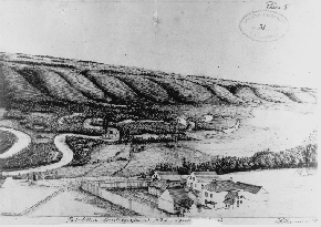
This sketch from 1882 captures the winding Assiniboine and its broad
valley.
Image From Manitoba Archives
And
perhaps he
was one of the first to really understand the ecology of the region. He
could see that the current cycle of prairie fires was responsible for
the lack of trees. He could envision the changes one would see if
settlers were to plough fields and cut the hay that fueled the fires.
Water would be retained in lakes and sloughs, in effect, the climate
and growing conditions would be altered. [5]
Another useful account of the times comes from a recent recruit with
the newly-formed North West Mounted Police. In 1874. Mr. Jean
D’Artigue’s troop had passed along the Boundary Commission
Trail that skirts Manitoba’s southern border, stopping for a time
at Roche Percee in southeastern Saskatchewan, before heading on to
Edmonton. Fort Ellice was the only place in the area to re-fit and to
get fresh horses, which the outfit sorely needed. They had expected to
meet someone from the Fort at Roche Percee, but none had arrive, so
D’Artigue and a small company were sent on a detour to Ellice.
He happily notes that Fort Ellice was the “first human habitation
which we had met since we left Dufferin.” Like other observant
travelers he had already noted the unusually wide and deep river
valleys through which our little prairie streams surge in the
springtime and trickle in the fall. He correctly guessed that they must
have once carried much more water but seems to believe that the climate
must have once been much more warm and moist. We can forgive him for
perhaps being unaware of the nature of the cataclysmic changes which
the retreating glaciers and melting ice wrought on the landscape, and
credit him with having pretty good geological instinct in an untrained
sort of way. [6]
His account of the fort is cryptic, “It is composed of a few
wooden buildings inhabited by the Company’s employees surrounded
by a wooden palisade.” and he is not too impressed with the
agricultural potential deeming the soil poor and complaining that they
had to travel five miles from the fort to get good grass for the
horses. Like so visitors from the east, unschooled in the
geography of the prairies, his impression of the land was dictated by
the season in which he passed through. As noted elsewhere the prairies
are both highly seasonal and widely cyclical in the face they present
to the traveler. A dust dry and nearly barren hillside in late August,
might well worn a lush green carpet of grass in May. An alkaline-rimmed
dry slough visited in September would be unrecognizable in early June,
rimmed with newly sprouted reeds and home to flocks of waterfowl.
Mr. Fleming was able to see past that, Mr. D’Artigue didn’t
have the benefit of such imagination and training. [7]
Winnipeg Daily Times,
Feb.
2, 1883

This Manitoba
Free Press
article from March 22, 1873 reflects the concerns of citizens who
were well aware of the confrontations taking place in the U.S. It
also reflects the tendency of the papers to print rumours, but at least
they admitted that they were rumours.
Perhaps
the
most detailed and widely-quoted impression comes to us from Nathaniel
McKenzie a carpenter who arrived by at Fort Ellice in 1874 direct from
the Orkney Islands to begin what was to become a lifetime of service as
in the HBC. Co. He and a blacksmith walked from Fort Garry, nominally
attached to a Cart Brigade loaded with food and supplies. He notes that
the post was “very much an Inland Post” [8] in that it was
quite isolated, perhaps receiving communication from the outside world
only once a year. He mentioned the blacksmith and carpenter’s
shops. He refers to the location as “beautiful..with
charming and lovely scenery.” describes the fort site as beings
“on a beautiful plain dotted with little poplar bluffs, high and
dry, with numerous springs of beautiful cold water gushing up at
the top of the level in the face of the banks.” [9] His
description of the fort itself seems to have been the basis for
most subsequent accounts and is worth repeating in its original form:
“The Fort was
built in a large square, the big front gates being
about thirty yards from the brow of the bank which was very precipitous
at this point, and well wooded with small trees, ferns of all kinds,
and saskatoon bushes. Raspberries and other berries were also
numerous along the banks, and in the valIey, when in season. On one
side of the square was a long row of one-storey log buildings, with
thatched roofs all joining each other. The carpenters' shop was at one
end of and the blacksmith’s shop at the other. The doors or
entrances all facing to the Fort. There was the men's house, the
mechanic’s house/the native servants and dog drivers houses, also
the married servants’ houses, each of which as I have mentioned consisted of one large
room in size suitable for the
number of servants supposed to occupy any one of then. A door opened
into each from the outside and there was no other means of entrance to
any of the other houses in that long row of buildings, except by its
own door or down the chimney.
Two
tiers of rough
bunks round the walls, were the sleeping
accomodations, while a large mud chimney, open fireplace, provided
ventilation. We also did all our cooking at the-open fireside. On the
other side of the square, in an equally long row, built in the same
style, were warehouses, ration houses, dry meat and pemmican house,
flour, pork and beef house, and a well appointed dairy, with a good
cellar and lots, of ice. These buildings were one-and-a-half storey
high and were without chimneys or fireplaces.

From the Winnipeg Daily Times, June 5,
1884

The
Manitoban, May
3, 1873
On
one side of the
big gate in front was the trading store and district office, and on the
other aide the fur store and reserve stock warehouse, each of these
buildings were very long and substantial, fully one-and-a-half storeys
high, and had been shingled the previous year, the shingles being
manufactured by Indians and haff-breeds m the carpenter shop the
previous winter, with the aid of axes and draw knives. They could make
the shingles very quickly—I was quite surprised to see the
finished article. I most say the shingles were well made and lasted for
years, giving a perfectly tight roof. The main building in the Fort was
the" Boss's or, the "big house," as it was called, being the quarters
of the Officers and clerks. It stood well back in the square, its front
being in line-with the end of the long rows of buildings on either
side, so that every house in the Fort could be seen from its front
windows. It was a two-and-a-half-storey, 60x40 feet building, with a
large kitchen behind, built from the same plan as the officers'
dwellings in Fort Garry, and known as a Red River frame building. It
was made of 8 inch logs, 10 feet long, set in a frame. It had a nice
balcony and verandah, the main entrance being in the center of the
building, and opening into a large recreation and council hall. The
boss's private office was to the right, and the parlour or sitting room
to the left. Large mess room, dining room, and private bedrooms were in
the rear.
Upstairs was a
large hall and reading room and bed rooms for the
clerks. The upstairs was heated with large Caron stoves, as well as the
hall downstairs, and the trading shop and district office. The same mud
chimneys—two of them—only more elaborate and massive than
those belonging to tike other buildings were in the big house. There
were four fire places on the ground floor, and another in the kitchen,
as well as a large cooking range. A splendid mud oven stood outside for
baking bread and cooking extra large roasts. There was alao a fine well
close at hand with the proverbial oaken bucket attached to a rope and
chain. The big house and kitchen were thatched, and all the houses were
mudded and white washed with lime, altogether they presented a good
appearance from a distance. A four foot side walk ran all around the
square, and another one from the front gate to the front door of the
big house. There was a nice vegetable, flower and kitchen garden of
about an acre behind the house. The flagstaff stood at the front gate,
and the Belfrey stood outside the Boss' private office. A high stockade
enclosed the whole square, so that when the big gate were locked at
night there was no danger of losing any scalps before morning.”
[10]

The "Big House" put to
commercial uses for a number of years after the H.B.C. ceased
operations in 1890.
Image From Manitoba Archives
His
mention of
scalps, though lighthearted in tone, does remind us however that there
was a reason that many (but not all) fur trade had stockades. Despite
the fact that relations with the native people were, in Canada, not
often marred by violence, there were episodes and there were concerns.
Foremost on the minds of HBC employees and early settlers alike was the
fact that the parties of Sioux from the U.S., seeking refuge after very
violent incidents across the border, were causing some concern. The
Winnipeg papers in 1873 engaged in a wordy debate over just how much of
a threat these somewhat unwelcome guests were. It turned out that they
posed little threat at all but people at the time weren’t quite
so sure. [11] (73.05.10 MB)
On one of his first trips outside the fort McKenzie seems quite
astounded by the countryside.
“ The view gave me at least a thrilling feeling of ecstasy and
delight, which made me fairly yell. ‘Oh, how
beautiful!’” [12]
In 1881 another passer by, author and lecturer Reverend Aeneas McDonell
Dawson noted that along the upper Assiniboine “There are
fine woods on either bank, often extending the whole breadth of the
valley.” [13] He appears to appreciate the scenery.
“From the heights at Fort Ellice,-about 250 feet above the
surface of the stream, a fine view is obtained of the most beautiful
undulating prairie lands, …” and in fact waxed quite
poetic:
“Stretching far inland are seen, as you glide along the waters of
the Assiniboine, beautiful valleys with winding banks, covered in some
places, with green herbage, and in others, with forests which ascend
the level of the plain above.” [14]
He was also quite optimistic on the issue of agricultural potential.
“The section of the North-West territory which borders on the
Upper Assiniboine, is destined, no doubt, to become one of the richest
agricultural countries in the world.”
The beauty of the area may well have been in the eye of the beholder,
but there were other factors at play. By 1881 a cycle of increased
rainfall had transformed the fertility of the plains. Mr. Dawson
may well have been that variety of traveler inclined to be
enthusiastic, predisposed perhaps to “boosting” the area,
but the landscape he crossed was indeed changed from that witnessed
just a few short years earlier.

From: Winnipeg Daily Times, May 17, 1882


From: Winnipeg Daily
Times, July 9, 1879,
May 18, 1880

From: Winnipeg Daily Times, Oct. 6, 1881
Our most
substantial and personal accounts of both the appearance and the
operation of Fort Ellice comes from a young man, Willie Trail, who came
west from Ontario in 1864 to accept and “engagement” (five
year commitment) with the H.B.C. He came not even knowing where he
would be posted and appears to have been very happy with Fort Ellice.
In a letter to his mother dated Aug. 7 1864, he notes how the fort was
visible from four to five miles off, and how after crossing the river,
it took what he estimated to be a 300 foot climb to reach the
buildings. His description is worth repeating:
“The Fort is a large log [house] full two stories high. The upper
part is at present used for a store room the store having been blown up
with gunpowder this summer with the loss of 2 lives and one or two
wounded. There is a high stockade of poplar about 15 ft high on two
sides of the fort the rest has not been completed yet. The fort stands
on one of the prettiest places I have seen. It is about 350 ft above
the river which runs immediately below us. The banks of the river are
all very steep and high and look very pretty. It is better than half a
mile across from hill to hill the valley being covered with small
shrubbery and the river, which is small, running the most impossible
curls and crooks you can imagine.” [15]
In other letters he describes the pemmican production process
allowing that, “Pemmican is not bad stuff” P31 He assures
his mother that he has “not fallen in love with any of the Indian
girls yet though there are some nice looking ones here. Everybody tells
me it is one of the best and prettiest places in the H.B.
territory.” His opinion on the H.B.C. policy that no one can
marry during first “engagement” (5 yrs?) is that it is a
sensible one, reasoning that families are expensive to feed.” His
letters are full of opinion and observation. [16]
In addition to its traditional fur trade function, the post’s
location along the main trail west, and situated in the heart of fine
agricultural land, allowed it to serve other purposes. By 1872 it was
the office for the district of Swan River, and it had become
headquarters for the numerous survey parties sent out to prepare the
west for colonization. The newly-formed Northwest Mounted Police were
stationed there for a short time, and often used the facilities in
their journeys to and from the west. In many ways it was becoming like
a town, serving as a way station, inn, stopping place, and frontier
supermarket. It was a postal centre, and a depot for the exchange of
horses. Red River carts were manufactured within its walls. It was
acquiring quasi-governmental status and was the main treaty-paying post
for several native tribes. [17]

From: Winnipeg Daily
Times, Dec 27, 1883,
& April 30, 1880

From: Winnipeg Daily Times, April 30, 1880
During the early
seventies the general consensus was that the trans-continental rail
line would pass along the line of the old Carlton Trail, and as such
would cross the Assiniboine somewhere in the Fort Ellice area. As time
passed a northern route was advanced which would pass through the
Interlake by way of the Narrows and eventually follow the Saskatchewan
River system. A lengthy letter in the Manitoba Free Press in 1878
pinpoints the advantage of the southern route through Manitoba in that
it would pass through good farmland which would provide immediate
business in both immigration and crops transport business. It is
interesting to note that the letter writer, who saw the advantage for
both Winnipeg and the new western settlements, anticipated the thoughts
of Jim Hill and the “new” syndicate who in the spring of
1881 adopted the same reasoning. [18]
In the meantime, although cart brigade and horseback remained the
fallback option for transportation the somewhat unexpected appearance
of the steamboat as an option helped Fort Ellice maintain its function
as a travel hub. It was unexpected because, although steamers began
making runs to Portage in 1878, the head of navigation on the
Assiniboine was generally thought to be Currie’s Landing at the
foot of the “Grand Rapids of the Assiniboine” just 7
kilometres east of the future site of Brandon. On May 15 in the watery
spring of 1879 Captain Griggs and his determined team fought their way
through that considerable obstacle and thereafter both the Marquette
and the Alpha were making runs to Fort Ellice, the new head of
navigation. [19] This service of course operated only when water levels
permitted, but during the wet years of 1880 – 1882 it was a
surprisingly long season. [20] Two warehouses and a landing were
quickly erected and well used. The addition of river travel for a short
period of time, increased its importance as a jumping off point for
anyone going west. The papers were full of accounts of surveyors, NWMP
troops, and horse traders taking the boats to Ellice and taking the
trail from there. [21] John Macoun, whose explorations observations and
subsequent reports would almost single-handedly convince the C.P.R.
executives to adopt a southern route, was on the first voyage of the
Marquette to Fort Ellice in 1879. The community hosted the Governor
General’s party on their tour of Western Canada in the
summer/fall of 1881 and the some of the party returned to Winnipeg by
taking the steamboat Marquette to the head of the railway which had
just reached Portage. [22]
The steamer era was a short one. By 1884 on no longer finds ads
offering direct service by steamer to Ellice, the Marquette for
instance appears to be traveling only as far as Millford and the owners
o the Alpha seem to have her working on the Red where they have tried
to resurrect the Winnipeg – St. Vincent route as competition to
the C.R.R. . The Alpha did end the season running some freight from
Brandon to Ellice in the latter part of the summer, but with the
railway getting closer the steamboat era was coming to an end.
[23]

From: Winnipeg Daily Times, June 26,
1883
With the
steamboats
out of commission and the transcontinental railway passing to the south
the settlements to the north of the line were increasingly served by
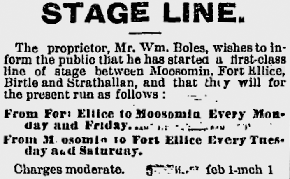
stage coach service with Ellice on a line that passed along the old
trail through Shoal Lake and Birtle. Telegraph service came in and an
additional stage line connected the community with the railroad town of
Moosomin in 1883 [24]
Thye various transportation links were helping Fort Ellice become more
than just and HBC Post. It was attracting both homesteaders and
businessmen. In the spring of 1880 an enterprising settler opened a
boarding house for “Travelers and Emigrants” offering
“accommodation and comfort” on “the elevated plateau
near the Hudson Bay Company’s establishment and Steamboat
Landing” and an “extensive view of the beautiful valley of
the Assiniboine” [25] The owner, Benjamin Warwick, was in
the news a few years later, reporting on the early harvest, evidently
farming at that time. [26] By the summer of 1881 the site was surveyed
into town lots in anticipation of the next logical stage in it’s
development as a retail service centre. Lots in the would-be town of
“Colville”, though carefully surveyed and drawn up, never
got a chance to sell. [27]
Though hindsight dictates that its days were numbered in 1881, those on
scene at the time had a much different view. In that year it was
visited by St. Paul writer Frank Austin Carle who traveled Canadian
prairies compiling stories, descriptions, and sketches for publication
in the Pioneer Press newspaper of St. Paul Minnesota. He refers to it
as the “Oldest and best known point” between Winnipeg and
Rockies.” [28]
He describes his approach to the Fort with his characteristic
restraint.
“None of the strangers to the country were prepared for the
striking spectacle that presented itself to their eyes, accustomed to
the dull monotony of the prairie scenery, as the road, after winding
through a thick growth of timber, suddenly emerged upon the brink of
the valley. The Assiniboine here flows through a valley nearly two
miles wide and 250 feet below the level of the plain.” he goes on
to call the scene “picturesque and striking in the extreme”
[29]
At that time the post would be at its largest and most well-developed
stage, with its large residence and numerous outbuildings, attractively
perched on the lip of the valley overlooking a farm plot, steamboat
landing, stores and warehouses. Mr. Carle learned that Fort Ellice was
“an important one” a central point for the dispersal of
trade to lesser posts to the north. He learned that the
well-timbered valley walls had been barren as recently a ten years
earlier and that the trees had taken hold only after a certain level of
settlement and well-traveled trails broke the cycle of prairie fires.
He reflects upon the change settlement will make to the land and
accurately foresees a prairie made more hospitable and productive
by\the spread of woodlands. He observed that the opposite bank of
the river was dotted with new houses “as far as the eye can
reach” and refers to the reach of settlement begun four years
earlier at Rapid City and expanding towards the more recent towns
of Minnedosa and Birtle. [30]

This clip from a Winnipeg Daily Times article
in the December 1, 1883
edition poked a bit of fun at the constant speculation, boosting, and
general elbowing for position as communities pinned their hopes on rail
lines.
Although
bypassed by the main line it continued to grow as an agricultural
centre. By 1883 the area was home to large productive farms, like the
1280 acre spread farmed by D.C, O’Keefe and his two sons, from
which he was shipping both grains and livestock. The Chief factor
of the HBC Post, Mr. McDonald was himself a farmer of note and a Wm.
McDonald had over a hundred head of cattle on his farm. By 1884 the
Winnipeg Daily Times reports that “a very large acreage under
crop” adding that a Mr. Stewart was erecting both a sawmill and a
grist mill. [31]
If the inevitable decline of Fort Ellice as a trading and
transportation centre was signaled with the decision of the C.P.R. to
build its transcontinental line to the south, its doom was assured when
the long-awaited Manitoba and North Western line reached Birtle in 1885
then turned northwards to cross at Millwood, spawning yet another
short-lived boom town. The settlement seemed to accept its fate
gracefully and without fanfare. In 1890 the HBC sold the store to the
storekeeper where it prospered for a short time as a county store and
way station on the Birtle-Moosomin stage line. By 1904 the Lewarton
brothers were operating the store and “offered the residence,
store, post office, stopping-house and stables…” for sale.
What small trade there was ended when the Grand Trunk Railway came to
St. Lazarre in 1909.The buildings soon were dismantled, moved, or left
to crumble. [32]
Today a cairn marks the spot and a few signs remain of the Big House
and two cemeteries. For years the site has been on private property but
recently the Municipality has shown an interest in developing the site
as a Historic/Tourist attraction. Perhaps the time will soon come when
travelers on Highway 42 just south of St. Lazare will see a sign
reminding them that something important once went on nearby.

Winnipeg Daily Times: June 13, 1879
Bibilography
1. Excellent on-line copies of this and
other maps
are available at:
http://www.flickr.com/photos/manitobamaps/2211818555/in/set-72157603404657457/
2. A type of stove made at the Carron Foundry in Falkirk, Scotland,
exported
to fur trade posts in Canada. The most common form consisted of a
rectangular
firebox made up of 6 cast-iron plates with a smoke hole and a fuel
door.
These stoves were very practical in the fur trade because they could
easily
be taken apart and shipped.
3. Meldrum, Ruth Fort Ellice, Ellice 1883-1983, R.M. Of Ellice
Historical
Society, 1983 P11-21
4. Grant, George M.: Ocean to Ocean, Sanford Fleming’s
Expedition Through
Canada in 1872, S. Low, Marston, Searle & Rivington, Canada 1877,
114
5. Grant, 115, 113
6. d' Artigue, Jean, Six Years in the Canadian North-West,
Hunter
Rose and Co 1882 43
7. d’Aritgue 65,66
8 McKenzie, Nathaniel M. J.,The men of the Hudson's Bay Company, 1670
A.D.-1920
A.D . Fort William, Ont.: Times-Journal Presses, 1921, 20 21
9. McKenzie 21
10. McKenzie 21-23
11. The Manitoban, 73.05.10
12. McKenzie 26
13. Dawson, Æneas McDonell, The North-West Territories and
British
Columbia (Ottawa: Printed by C.W. Mitchell, 1881) 30
14. Dawson 31
15. Traill, William E., Fur Trade Letters of Willie Traill
1864-1893
(Ed. K Douglas Munro –U. of Alberta Press. 2006 25
16. Traill, 31, 32
17. Meldrum, Ruth Fort Ellice, Ellice 1883-1983 R.M. Of Ellcie
Historical
Society, 1983, 19
18. Manitoba Free Press, 78.10.14 More details of this and other
steamboat
exploits are dealt with in other chapters
19. Winnipeg Daily Times, 79.05.27
20. Winnipeg Daily Times 81.09.20 , 79.06.13
21. Winnipeg Daily Times 79.07.09
22. Winnipeg Daily Times 81.08.18 & Meldrum
23. Winnipeg Daily Times 84.05.10, 84.06.28
24. Winnipeg Daily Times 80.02.25, 83.02.02 & Winnipeg Daily
Sun
82.03.06
25. Winnipeg Daily Times 80.04.30,
26. Winnipeg Daily Times 84.09.06,
27. Winnipeg Daily Sun 81.09.28WDS , (See also R.M.
of
Ellice History)
28 Carle, Frank Austin 1851-1930, The British Northwest: Pen and sun
sketches
in the Canadian wheat lands: The illustrations from photographs taken
upon
the spot . St Paul, Minn.: Pioneer Press Publishing Co., 1882. 55
29. Carle 70
30. Carle 71
31. Winnipeg Daily Times 83.03.01, 84.05.09, 84.06.05
32. Abra, Marion, A View of the Birdtail, A History of the
Municipaility
of Birtle, 1878-1974, History Committee of the Municipality of Birtle,
1974
79
On Nov. 19, 2012 the Winnipeg Free Press reported that the site of Fort
Ellice was purchased by the Nature Conservance of Canada
http://www.winnipegfreepress.com/breakingnews/fort-ellice-will-greet-visitors-again-179909491.html
|
|
|
|
|